Discover Historic Williamstown Week 6


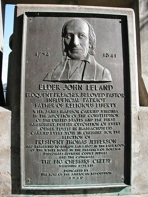
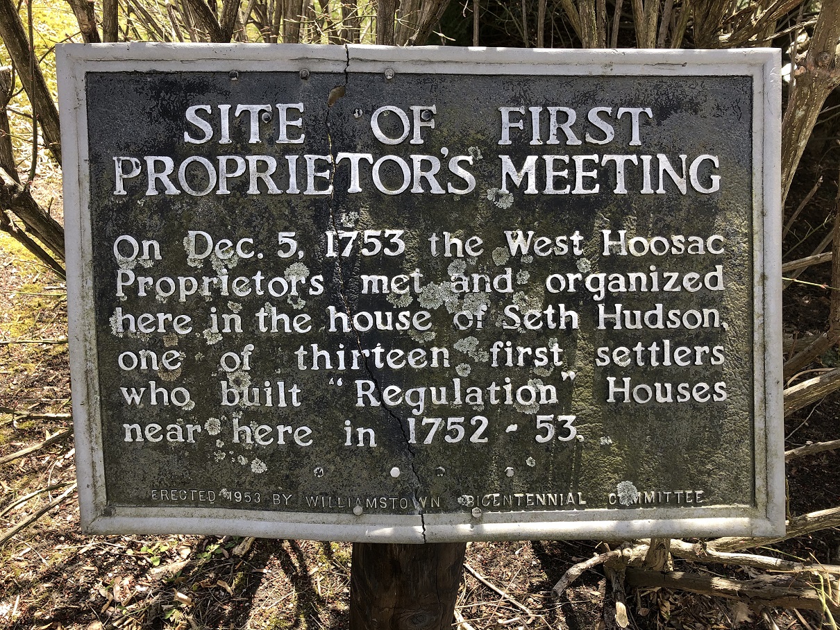
We bet this week’s historical marker will be puzzling to folks for many reasons. Where was Seth Hudson’s house? Who was Seth Hudson? Who were our first settlers? Who were the West Hoosac Proprietors?

And, most importantly, what is/was a Proprietor?

Here’s what Roy Hidemichi Akagi said in The Town Proprietors of the New England Colonies (1924, University of Pennsylvania Press) which is still the authoritative work on this topic.

“[In 1753] the majority of land grants from the General Court of the Massachusetts Bay Colony were made to groups or communities for the purpose of the formation of new plantations and townships. The grantees of these township and plantation grants became known as the proprietors.

These grants gave to the proprietors both necessary ownership and local government powers. This meant that the next stage in the evolution of title was grants from the town proprietors.

Originally, there was no difference between the town and the proprietors, so that a grant from the town was a grant from the proprietors. But as the towns grew and persons who were not among the original grantees of the township came to live in the town, a difference arose between those having the right to vote as to town administration and business affairs and those who had ownership rights in the town lands.

Gradually a separation occurred and the proprietors claimed the exclusive right to convey the land belonging to the original grantees. With their organization as an independent body, they rather than the town members, exercised jurisdiction over the common and undivided lands in any township.”

If you are interested to read further, Akagi’s book is available as a free, downloadable PDF here:The Town Proprietors of the New England Colonies

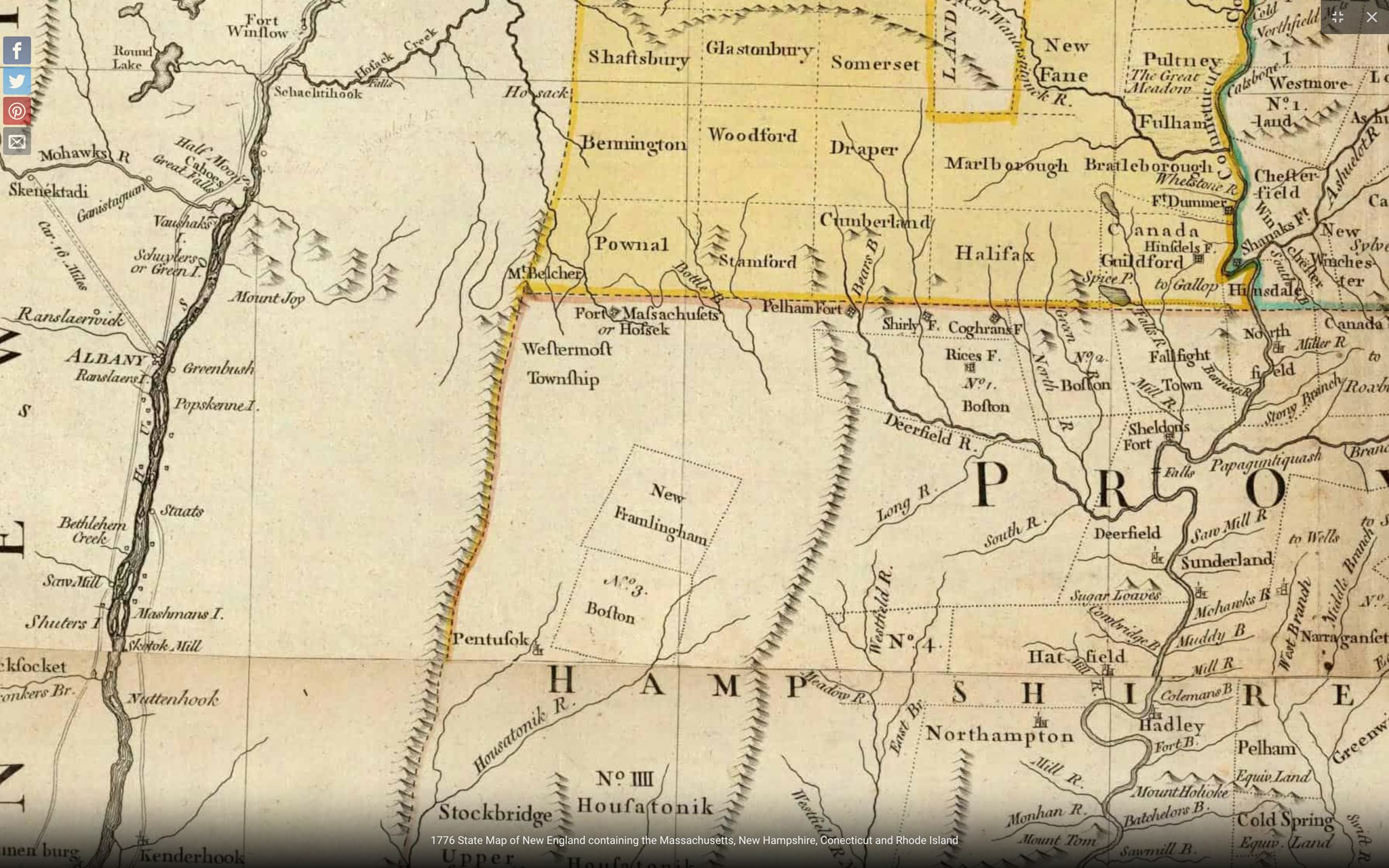
A close up from the 1776 map of our region in Jeffrey’s “The American Atlas: Or, A Geographical Description Of The Whole Continent Of America.”

Who were the West Hoosuck/Hoosac proprietors?

According to Arthur Latham Perry in “Williamstown and Williams College,” 1899″

“…on the 10th of September, 1753, the House of Representatives at Boston voted that William Williams [of Pittsfield, first cousin once removed of Ephraim Williams], “one of his Majesty’s justices of the peace for the County of Hampshire [it was eight years later when Berkshire County was set off], issue his warrant for calling a meeting of the proprietors of the west township of Hoosac so-called…

This vote was concurred in by Governor [William] Shirley and the Council the same day ; and on November 15, 1753, [Williams] issued his warrant to Isaac Wyman of West Hoosac, requiring him “to notify and warn the proprietors of said township that they assemble at the house of Mr. Seth Hudson in said township on Wednesday, the fifth day of December next at nine of the clock in the forenoon to act”…

Such meeting was accordingly holden at that time and place, and inaugurated a successful local self-government, which continued for twelve years the sole authority within “the west township of Hoosac.”

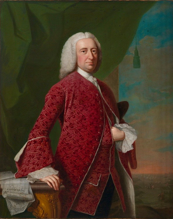
Portrait of William Shirley (1694-1771),
colonial governor of the Province of Massachusetts Bay
by Thomas Hudson, 1750, from the National Portrait Gallery

The proprietors mentioned by name in the record of their first meeting…are : Allen Curtis, Seth Hudson, Isaac Wyman, Jonathan Meacham, Ezekiel Foster, Jabez Warren, Samuel Taylor, Gideon Warren, Thomas Train, Josiah Dean, Ebenezer Graves, — eleven [white] men.

With the exception of Allen Curtis, who was the moderator of the meeting, and who not very long after returned to his former prominent position as a citizen in Canaan, Connecticut, all these had been soldiers in Fort Massachusetts before and all took military service in some form when the French War broke out again in 1754.”


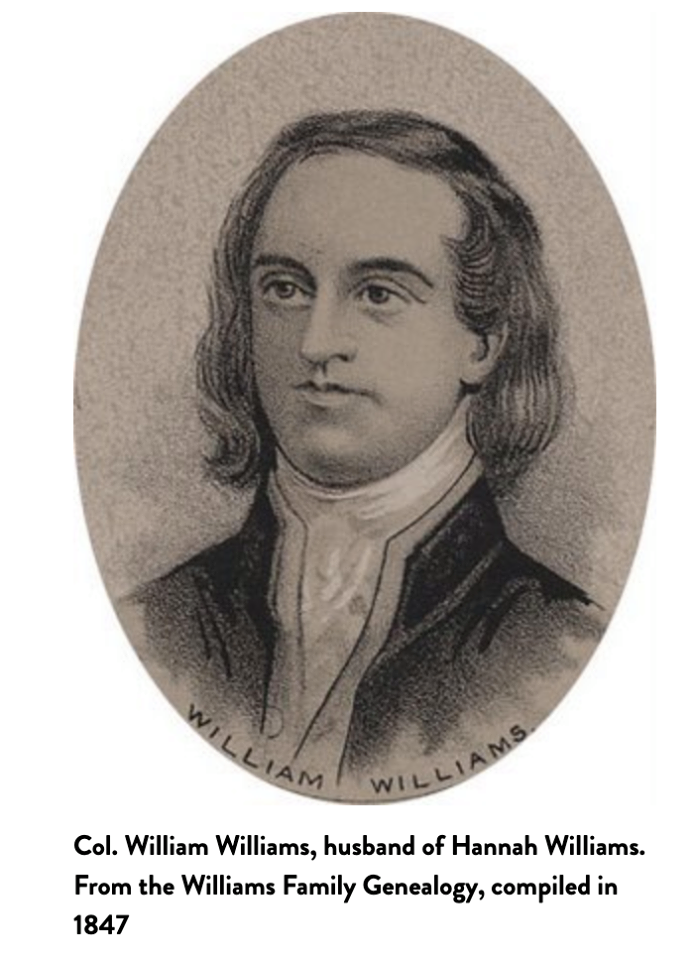
Etching of Colonel William Williams (1710-1785)
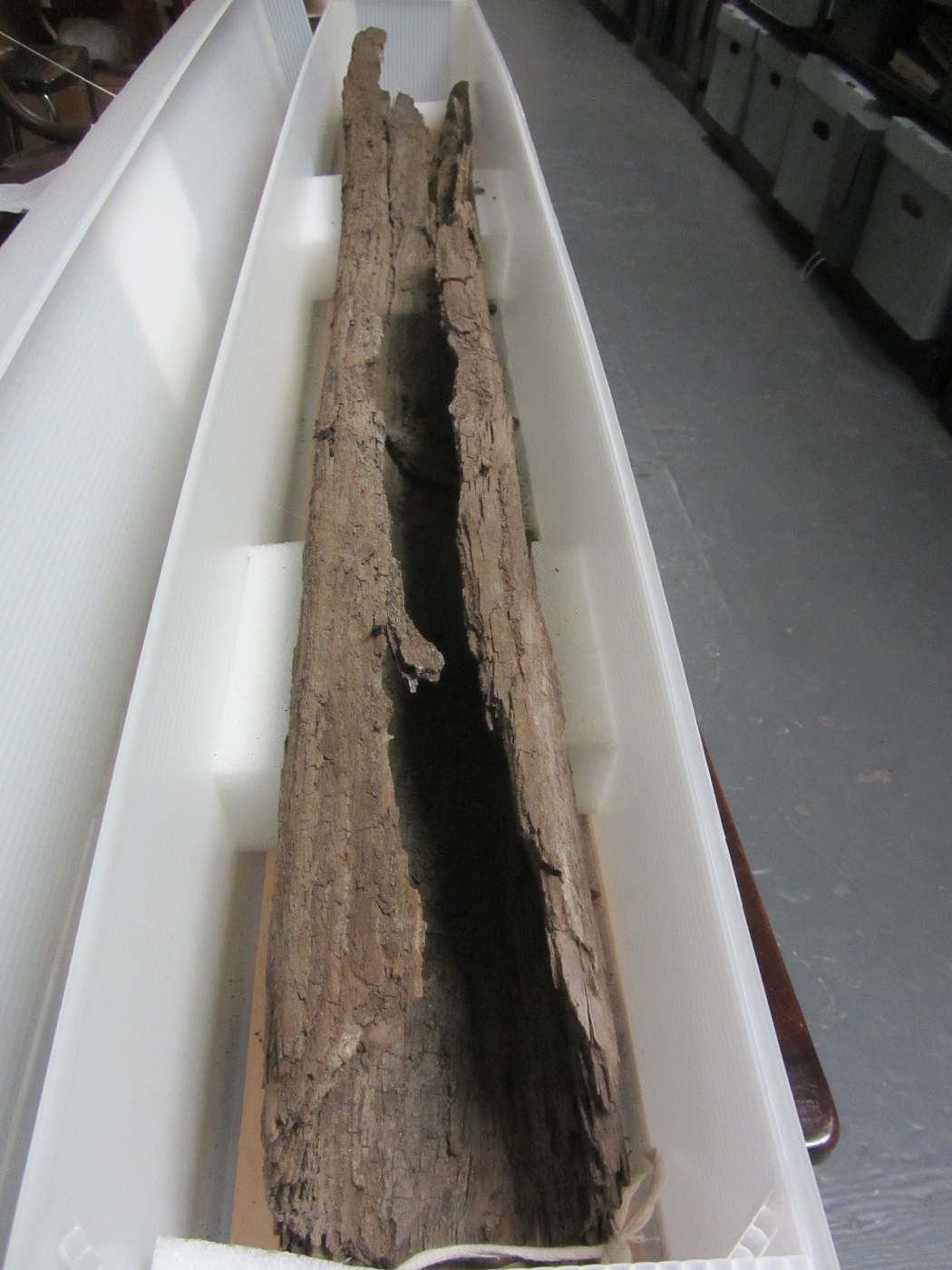
Thanks to Patricia Leach and The Clark​ Art Institute for this glimpse of the West Hoosuck Proprietors’ Book and a surveyor’s chain.

“The organization of a village and government had been approved on September 10, 1753, and a meeting of the proprietors was called to ‘determine upon a division of land or part of the lands in said township.’

Over the course of years to come, lands were divided many times and in a number of ways. About a quarter of the first lots were offered to soldiers from Fort Massachusetts in lieu of pay in cash, while many others were sold via lottery in the eastern part of the bay colony. Some of the other first lots were sold to settlers from Canaan, Wethersfield, and New London, Connecticut.

Further divisions of lands were devised to equitably allot the natural resources of the township so that each of the proprietors received a share of fresh meadowland, prime agricultural land, other agricultural lands, pine woodlot, oak woodlot, and forested land on steep slopes.

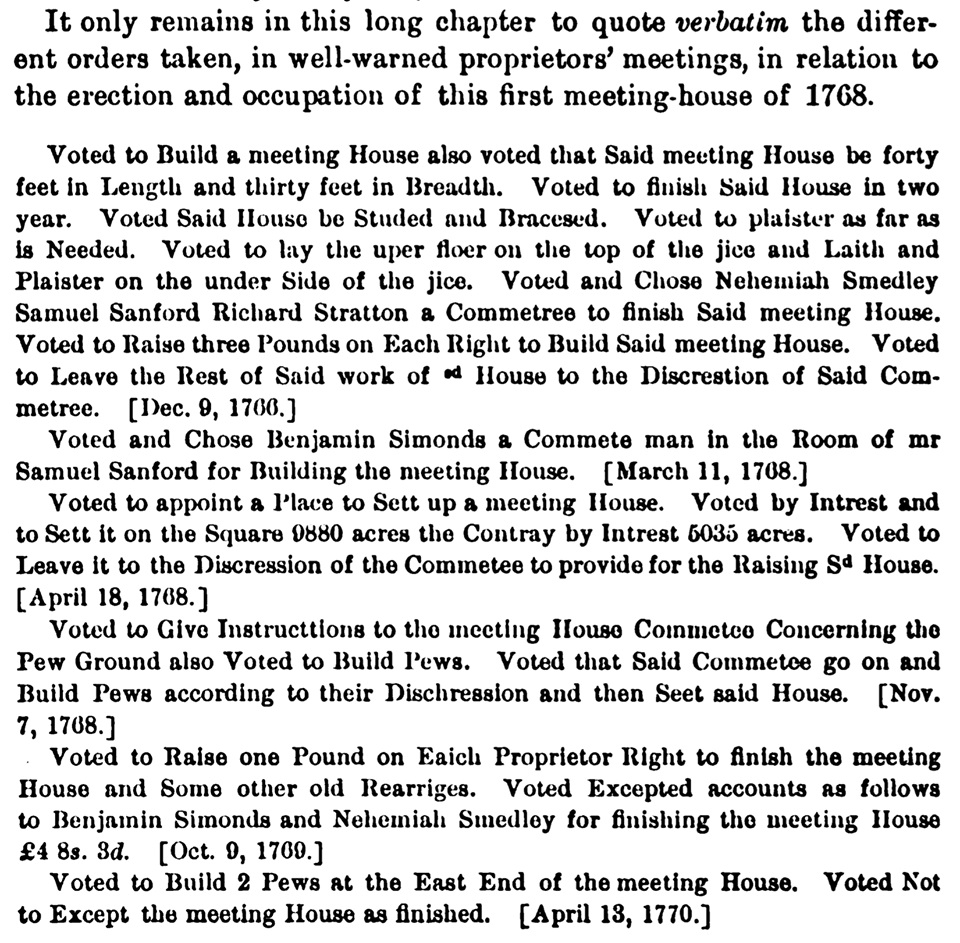
Lots were measured using a surveyor’s chain, and the measurements were recorded in this book.”

Audio File of Pat Leach’s excerpt on the surveyor’s chain.

You can learn more about the exhibit that included the surveyor’s chain here:
Clark Art Sensing Place Exhibit

Let’s meet the eleven white men who were the Proprietors of West Hoosuck at the first meeting in December, 1753. In 1753 the Massachusetts Bay Colony would only allow white men to own land in its boundaries.

ALLEN CURTIS, the moderator of the meeting, was the only Proprietor not to have been a solider at Fort Massachusetts. He was born on May 18, 1708 in Wethersfield, CT and died in 1783 in Canaan, CT. He hosted the second Proprietors meeting at his home, which stood directly across Hemlock Brook from Seth Hudson’s house.

“Captain Curtis brought his military title from Connecticut, and after a couple of years carried it back there, where he honored it by a life of usefulness.” – Arthur Latham Perry, “Origins in Williamstown,” 1894.

“The infighting between the settlers of West Hoosuck…and the powers in Fort Massachusetts continued unabated…The continuing friction was most evident between natives of Connecticut, who were in the ascendancy in West Hoosuck, and the ‘Bay’ natives at Fort Massachusetts.” – Michael D. Coe, “The Line of Forts,” 2006 (See illustration of the line of forts.)

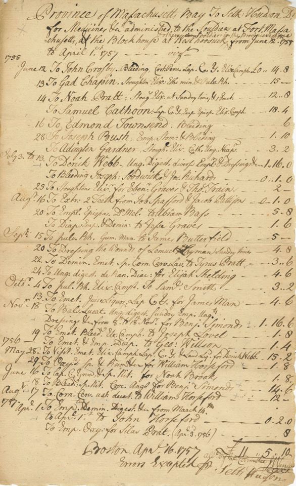
SETH HUDSON treated soldiers at both Fort Massachusetts and Fort Hoosuck. A bill for his medical services survives and is pictured here. He was very influential in the settlement of our town and the last survivor of the original proprietors. In 1756, upon the death of William Chidester, Hudson became the commander of the fort at West Hoosuck.

ISAAC WYMAN, the clerk of that first Proprietors meeting, was the second in command at Fort Massachusetts, having been appointed by Ephraim Williams, Jr.. Born January 18, 1725 in Woburn, MA and died March 31, 1792 in Keene, NH, he married Sarah Wells in 1754 in Deerfield, MA, where the first of their ten children was born. The second was born here in “Hoosuck, Massachusetts” and remaining eight were born in Keene.

“…during the decade of the 1750’s…rancor grew between Williams loyalists like Captain Isaac Wyman and an anti-Williams group led by Seth Hudson.” – Coe “The Line of Forts” 2006

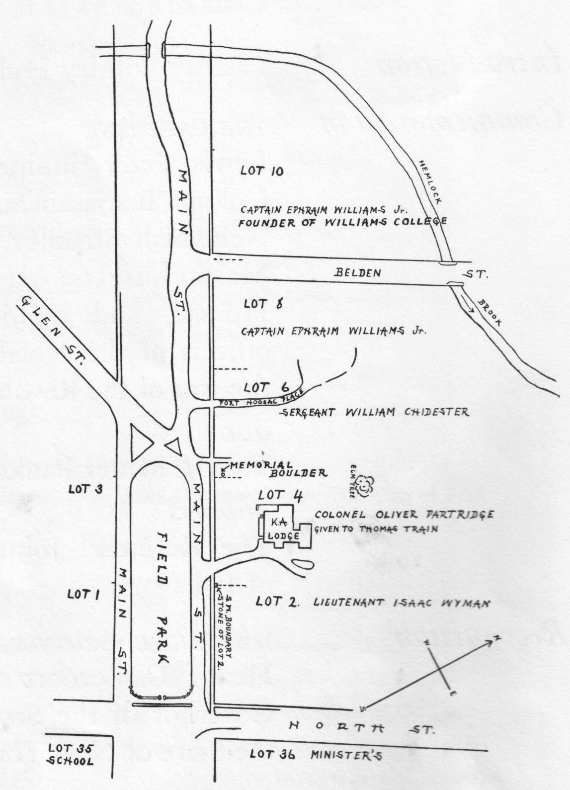
“Wyman…commenced [building] pretty soon on his lot, No. 2, which stretched along flanking North Street on the west side, and the front of which is now graced by the lodge of Kappa Alpha.” – Perry, Origins in Williamstown, 1894

“After 1759 [Wyman] continued to farm the ten acres surrounding Fort Massachusetts (acreage tat had originally been set aside for the use of the fort), but on November 13, 1761, he sold all his West Hoosuck property and moved to Keene.” – Coe “The Line of Forts” 2006

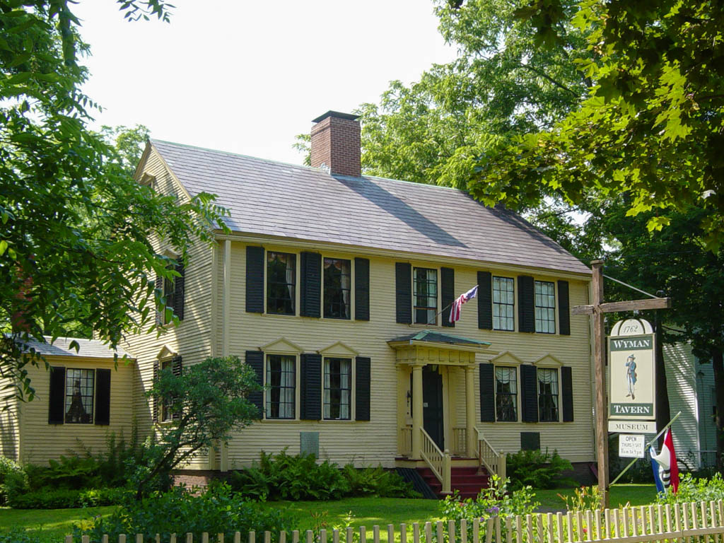
In 1762 Wyman opened a tavern on Main Street in Keene, which is now a museum (see photo). In 1770, the tavern was the gathering place for the first meeting of Dartmouth College’s Trustees. Although advanced in years, Wyman marched at the head of his company to Lexington in 1775, and later served in the Battle of Bunker Hill.

In “Origins in Williamstown (1894) Arthur Latham Perry wrote:” EZEKIEL FOSTER was from Fall Town, now Bernardston and quite constantly a sentinel in the line of forts from the beginning to the end. He drew house lot no. 13 in the original ‘lotting’ of West Hoosac…he was one of the first ‘eleaven families of us,’ already domiciled at West Hoosac, who petitioned Governor Shirley from Fort Massachusetts to which these families ‘ran for shelter upon the late alarm’ in October, 1754, for aid and military encouragement to ‘return to our settlements at the west town.’ Foster became a considerable landowner and a prominent citizen of Williamstown…”

Foster sold Lot No. 13 to Allen Curtis, another original Proprietor, but he “…continued a settler and citizen for many years. but bought lands, and had a home in different parts of town.”

Thanks to Paul W. Marino for a comprehensive, illustrated look at Fort Massachusetts.  Fort Massachusetts by Paul Marino


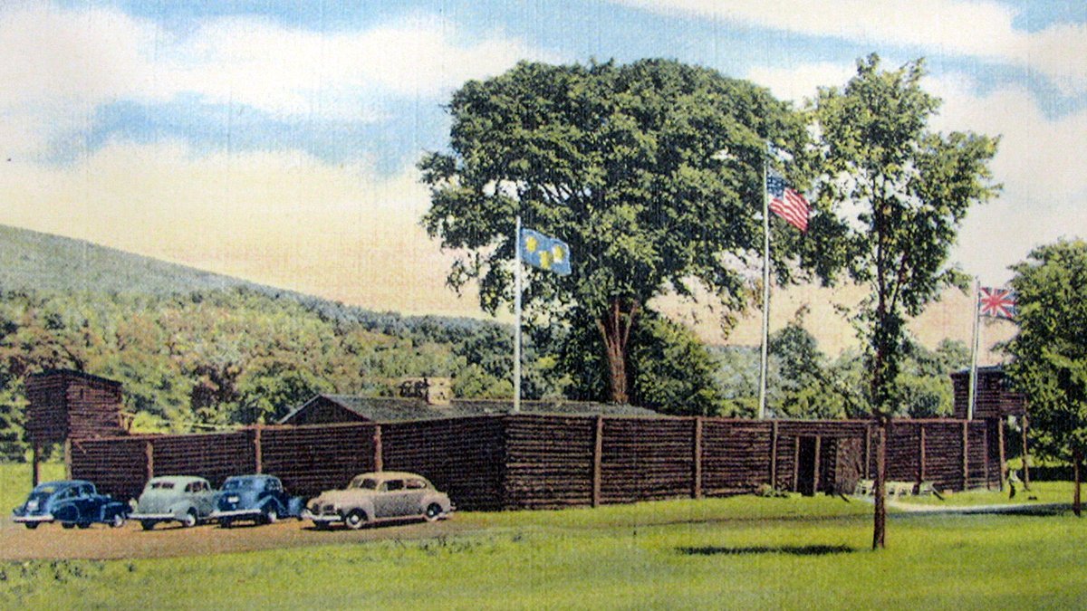
Postcard depicting 1930’s reconstruction of Fort Massachusetts.

JABEZ and GIDEON WARREN came from Connecticut via Brimfield, MA, and ended their lives in Vermont. Jabez was Gideon’s father, and another son, Jabez, Jr. also moved here, which adds to some confusion since our early records are incomplete.

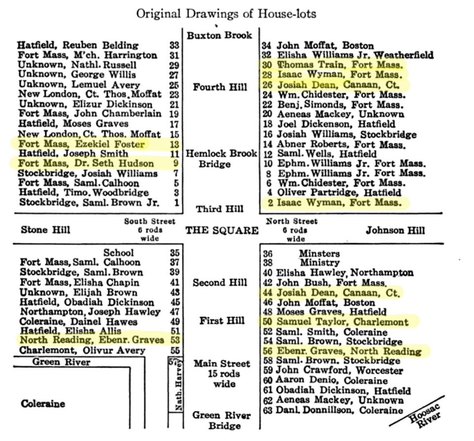
West Hoosac House-Lots with Proprietors’ names highlighted. From “The Hoosac Valley: Its Legends and Its History” by Grace Greylock Niles, 1912

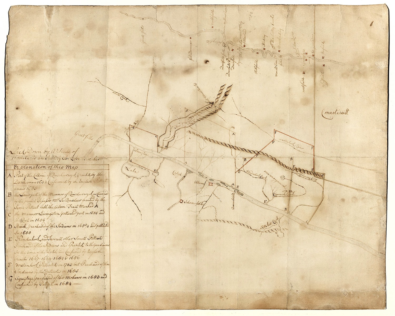
Manuscript map by Albany surveyor John Rutse Bleecker, showing Fort Massachusetts and the Hoosick circa 1745-55, around the time Williamstown (West Hoosac) was settled. Chapin Library collection.

 Here we meet some of our founding mothers for the first time, and encounter names – Blair, Meacham, and Simonds – which remain on our maps today.

JOSIAH DEAN was among the first European settlers to be granted land in what is now Hancock, and he may be the same man of that name to buy at auction in Boston the land that became the towns of Lenox and Richmond for £2,550.

His most significant action in West Hoosuck (Williamstown) was selling Lot 44 to Daniel and William Horsford of Canaan, CT, for “£260 Connecticut money old tenor.” That is the lot on which the Williams College Presidents’ house now sits. William and Esther Smedley Horsford became the second white couple to start a family in town.

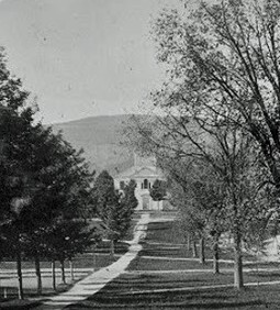
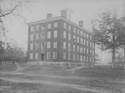
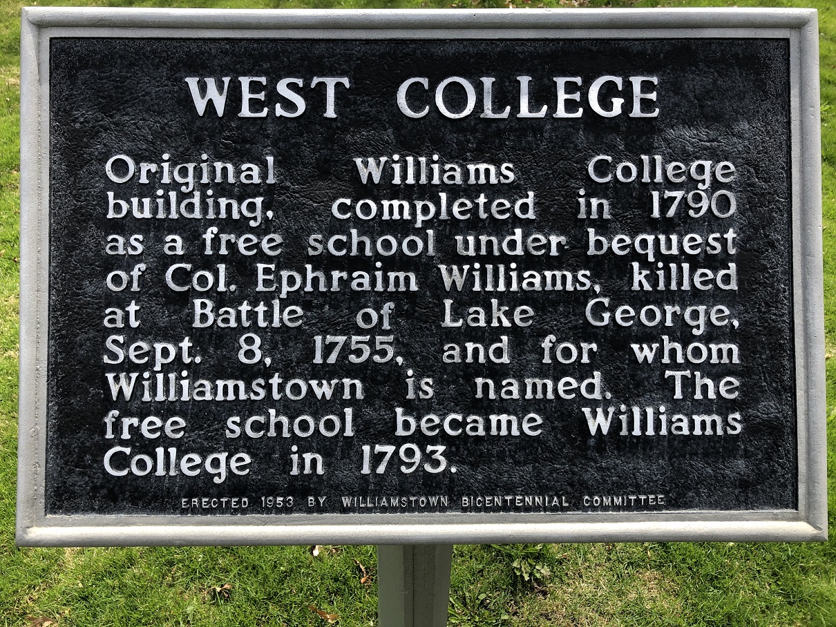
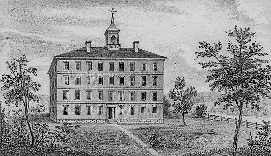
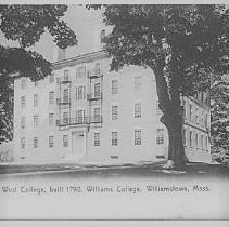
JONATHAN MEACHAM, originally from New Salem, MA, bought house lot No. 43 from Seth Hudson for £5, and built his home very close to where West College now stands. Meacham most likely encountered the same problems finding water that the college did, and so he moved to lot No. 49, close to what was called the “college spring.” Later he went to farm on Bee Hill, where many generations of the Hickox family later lived.

Meacham and his wife, Thankful Rugg, were original members of the church, but in February of 1779 a committee was formed “to wait upon Jonathan Meacham to enquire the reason of his absenting himself from communion.” The Meachams were not dismissed from the church, but “are designated among those ‘removed to distant parts.'” While his cousin, James Meacham, “left a large posterity which has continued to be identified with the town…Jonathan left none.”

Jonathan Meacham was with Ephraim Williams at the Battle of Lake George in 1755.

THOMAS TRAIN, born August 1727, was originally from Weston, MA. After an engagement went awry, Train enlisted and came to serve at Fort Massachusetts, where he drew house lot No. 30 in West Hoosuck, close by Benjamin Simonds and his family.

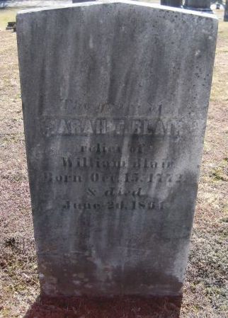
Although he was twenty-four years her senior, Train married 19-year-old Rachel Simonds, daughter of Benjamin and Mary Davis Simonds, the first child born to a European settler in town. They set up housekeeping on the southern slope of Townsend Hill (lot No. 63) where their daughter Sarah “Sally” Train was born in October 1772, exactly nine months after her parents’ wedding.

Before Sally was born Thomas Train had gone off to Virginia and acquired “a good title to some lands.” But on his return journey north he apparently died “and lies buried no one knows where.”

After two or three years of widowhood Rachel married Benjamin Skinner and Sally was raised with the children of that marriage. In July 1792 Sally married William Blair and died in 1864, at the age of 91 “universally respected and beloved.” Her tombstone in Westlawn Cemetery is pictured. Her husband, her son James, her mother, and many other family members are also buried in town.

The museum collection contains a linen sheet from the Blair farm. The flax to make the sheet was grown, processed, and woven in Williamstown by Maria Blair who was the daughter of Sally and William Blair.

Born in 1716 in Northfield, MA, Sergeant SAMUEL TAYLOR served at both Fort Massachusetts and West Hoosuck Fort, where he was the first commander, continuously from 1746-1757. His wife was with him much of the time and their daughter Susanna was born in Fort Massachusetts in 1754, and their son, Elias, in West Hoosuck Fort two years later. Elias Taylor was the first white male baby born in this community.

The year after Elias was born Seth Hudson recounts that Taylor was ordered by Isaac Wyatt to forcibly remove Jabez Warren and his family from rooms William Chidester had agreed they could occupy in his home. According to Hudson’s account, Taylor “…Halled out man, woman & Children Stole their Cloaths & broke to bitts & Destroyed some of Mr. Chidester’s goods…”Not surprisingly, Taylor moved his family out of town shortly thereafter.

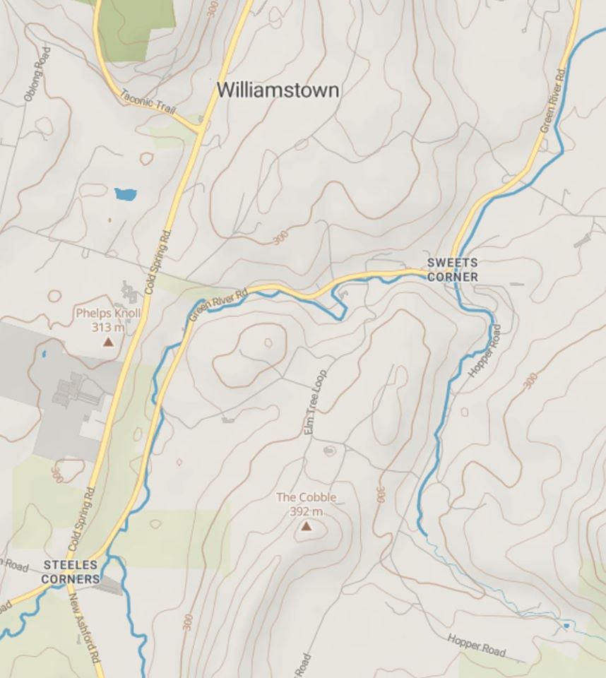
Samuel Taylor was the first owner of lot No. 63 at the junction of Hopper Brook and the Green River, known as “The Crotch” or “Taylor’s Crotch” and now called Sweet’s Corners (see map). Ten acres there were set aside as a “Mill Lot.” After the Taylor family moved away, Asa Douglass of Hancock, the father-in-law of Samuel Sloan, purchased an interest in this lot. On October 15, 1767, the proprietors voted to grant William, John, and Peter Kreiger, a Dutch family who operated Kreiger Rock Mill in Pownal, “liberty to sett up a corn-mill and saw-mill at Taylor’s Crotch” before August 1st of the following year.

Water-powered mills of all varieties were vitally important to the growth of towns in the 18th and 19th centuries. Our most recent WHM newsletter contains a fascinating article on the early mills of Williamstown by Mary Fuqua.  Early Williamstown Mills article.

EBENEZER GRAVES, was born March 15, 1726 in Hatfield, MA. He served at Fort Massachusetts from 1746-1752. Graves was one of the thirteen original settlers of West Hoosuck to build regulation house here between September of 1752 and September of 1753, having drawn lots Nos. 53 & 56. In January, 1753, he married Prudence Hastings of Greenfield, where the couple later settled and where Graves died on October 19, 1814, aged 88 years.

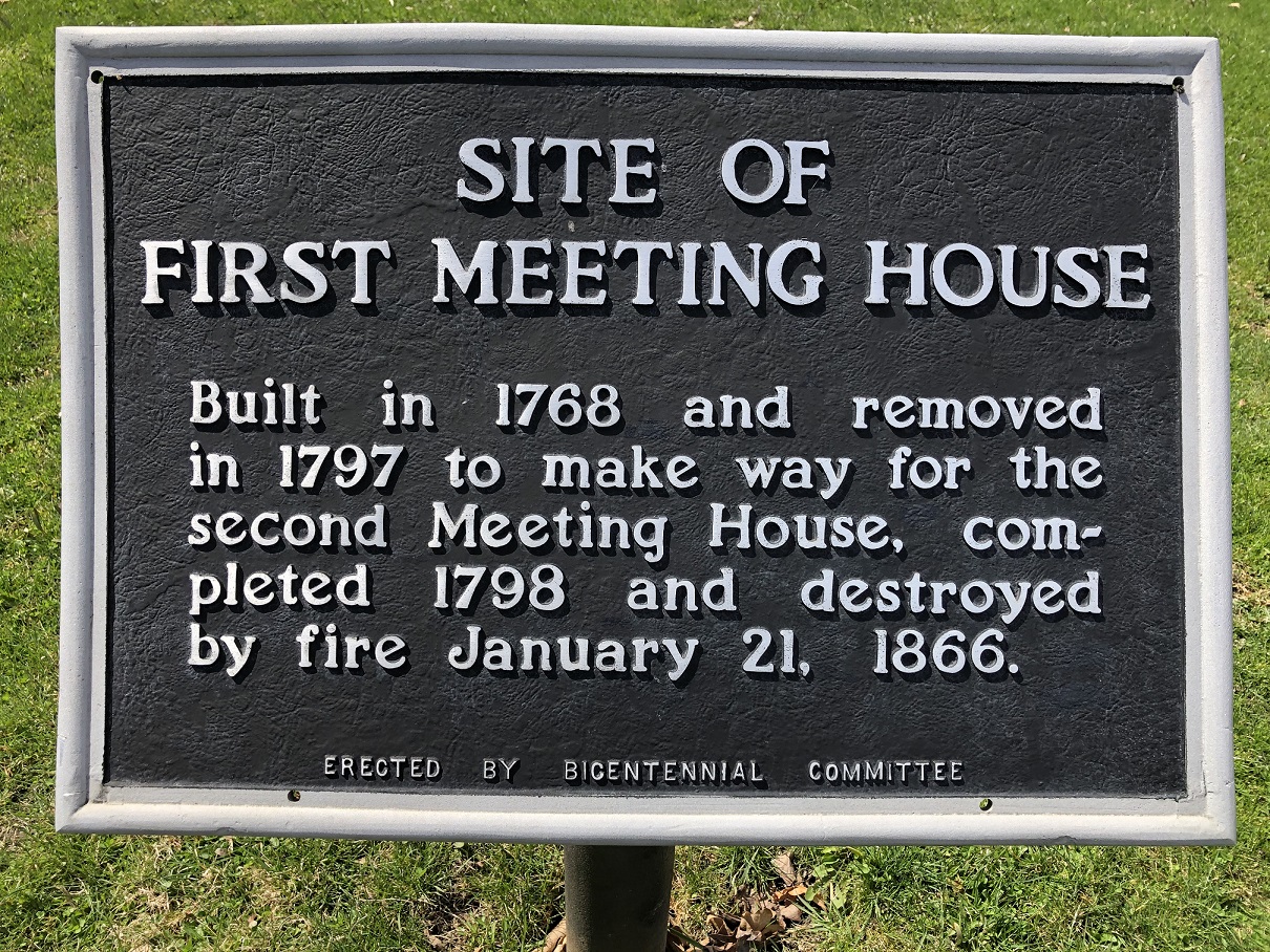
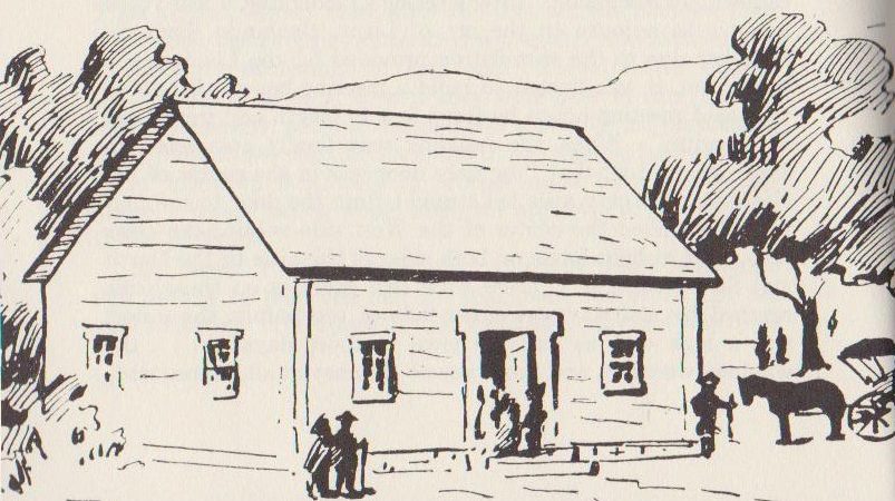
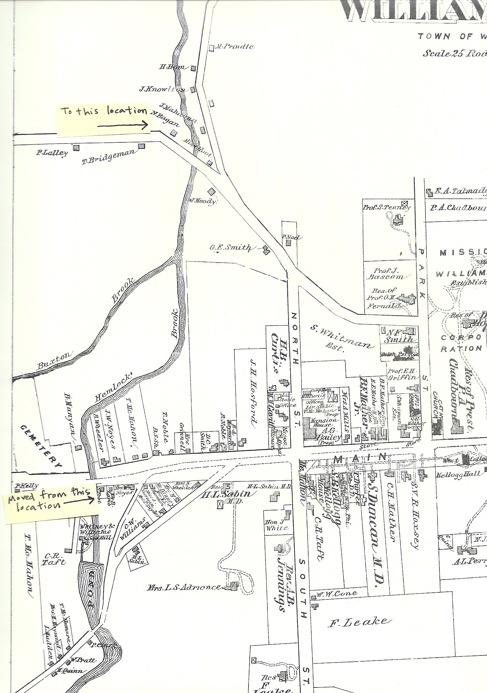
The original house in which the First Proprietors meeting took place was moved to Bulkley Street from the southeast corner of the Hemlock Brook bridge on Main Street via Hemlock Brook.  The current address of the building (or what might remain of it within) is 56 Bulkley Street, and is drastically changed from the original regulation house.


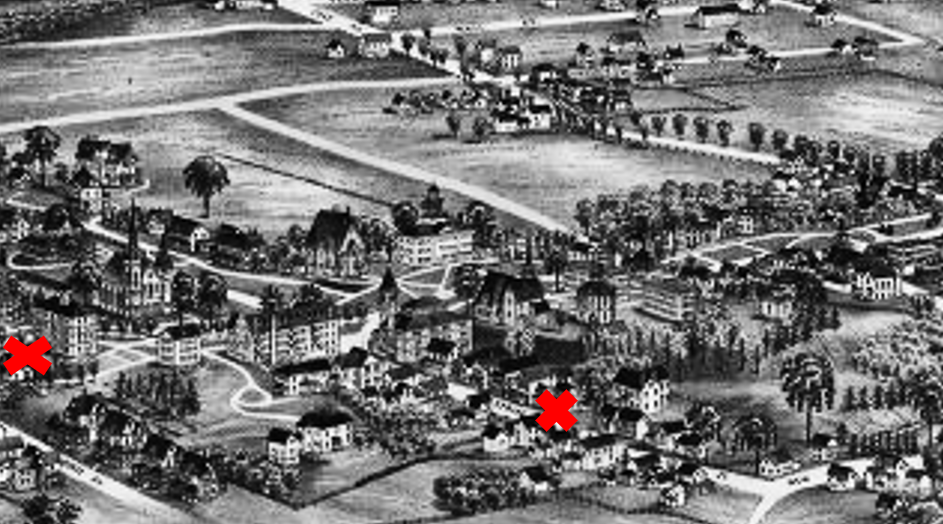
The map below shows the path of the move of the Seth Hudson House down Hemlock Brook to Bulkley Street.

If you can find the site of the First Proprietor’s Meeting, and its marker, we hope you will send a picture to us at info@williamstownhsitoricalmuseum.org.  For extra credit, can you find the “new” location of the house on Bulkley Street?

Discover Historic Williamstown! Week 5

This week’s historical marker is much harder to locate than some of the others. Do you know where the First Meeting House was located in Williamstown and its importance in our town’s history?

There was no separation of church and state in the late 1700s, and the Commonwealth of Massachusetts decided that in order to incorporate as a town a community had to have a meetinghouse and a “learned and settled pastor.” This meant what we now call a Congregational minister. There was no choice, that was the religion of the Commonwealth.

The town needed to incorporate under the name of Williamstown in order to access the money left to them in Ephraim Williams’ will to establish a free school, and they needed a church and pastor in order to incorporate. And yet it took a decade those conditions to be met.

“In 1765 the town was regularly incorporated by the Province authorities at Boston…The proprietors and not the townsmen called and settled the first minister, Rev. Whitman Welch…and paid all the expenses of his ordination; they built and paid for the first framed meetinghouse in 1768…” – Arthur Latham Perry “Williamstown and Williams College” 1899

Moira O’Hara Jones gave a great talk for us in 2015 about the relationship between the town and what is now the First Congregational Church, on the occasion of that institution’s 250th anniversary.

First Church and Williamstown: 250 Years Together Video

During the years between the settling of West Hoosuck and the construction of the first meeting house which enabled us to incorporate as Williamstown, there was a log cabin referred to as “The Schoolhouse” built around 1763 and located on Lot 36, which can been seen at the bottom right hand corner of this map, where it says “minister’s,” as indeed that lot had been originally reserved for the first minister. (The building would have been about where Mark Hopkins Hall is on the current Greylock Quad.)

Despite its name, it was never used as a school, but as Arthur Latham Perry wrote in “Origins in Williamstown” (1894): “…the proprietors uniformly held their meetings at this schoolhouse for several years; and public worship was held in it, whenever there was any, until the first rude meeting-house was built, 30’ x 40’, in 1768.”

Even after the first meeting house was built, Perry continues: “The log building acquired a certain sort of sanctity thereby, which was never wholly lost as long as it remained standing.”

As was evidenced on the afternoon of August 16, 1777, when the pious women of Williamstown gathered in the Schoolhouse “to pray for the safety and victory of their fathers and brothers and kinsfolk in the battle of Bennington, then raging.”

The Schoolhouse was probably taken down in the mid-19th century when the original “Mansion House” hotel was erected at the front of that building site.

“The proprietors and not the townsmen called and settled the first minister, Rev. Whitman Welch, in 1765, and paid all the expenses of his ordination; they built and paid for the first framed meetinghouse in 1768…” – Arthur Latham Perry “Williamstown and Williams College” 1899

The accompanying excerpt from Perry’s “Origins in Williamstown,” 1894, features snippets from Proprietors’ Meeting minutes c 1766-1770 pertaining to the building of the first meeting house, located in the middle of what is now Field Park. This drawing is the only representation we have of the first meeting house since it was replaced by the second meeting house before the invention of photography.

The first meeting-house was 30′ x 40′. At first it would have had rough bench seating, but then pews, probably box pews, as the First Congregational Church has today, were built and “seated.”

“Colonial churches were generally ‘seated’ each year; that is, each worshipper was assigned a particular seat, determined in accordance with their social or perceived spiritual status in the community.” – John Ogsapian, “Church Music in America, 1620-2000” 2007

There was a “seating committee” for the first meeting house in Williamstown, but not for the second.

While there was talk of “having the gospel preached in this town” as early as the second Proprietors’ Meeting in April 1754, no concrete action was taken until the Proprietors’ Meeting of March 10, 1763, after the French and Indian War had ended, when it was voted “that for the future” they “would have preaching,” and accordingly a call was given to Rev. Moses Warren to preach on probation.

Whitman Welch, the sixth child and youngest son of Thomas and Sarah (Whitman) Welch, was born on June 5 1738 in Milford, CT. He was orphaned by the age of ten when he went to live with an uncle in New Milford, CT, and where in time he was married to Ruth Gaylord.

Welch studied theology, graduated from Yale in 1762 and was licensed to preach by the New Haven Association of Ministers on September 25, 1764.

Immediately after the incorporation of Williamstown, the Proprietors called Welch “to the work of the ministry in this town” on July 26, 1765. He was ordained in October or November of that year, “at which time a church was gathered,” although the first meeting house wasn’t finished until 1768.

While Welch was given the use of Lot 36, the “Minister’s Lot,” on what is now the northeast corner of Main and North Streets (the northern junction of Rts. 2 & 7), he promptly sold it to Josiah Horsford for £25 and bought 18 acres of farmland on the Green River, where he made his home next door to Nehemiah Smedley.

When the Revolutionary War began in 1775, Welch sold his farm to Smedley and joined the militia as a chaplain. He died of small-pox near Quebec on April 8, 1776, at the age of 38. His widow and children had returned to New Milford when he joined the war effort and never returned to Williamstown.

This map shows Williamstown in the upper left hand corner, and New Milford, CT in the lower left, on the Housatonic River just north of Danbury. A number of families followed Whitman Welch north when he was called to preach in Williamstown.

Williamstown struggled to attract a “learned and settled pastor.” According to Arthur Latham Perry: “They had had hard luck and had been at much expense even to get a suitable man to try for a settlement. In two cases where the candidate was willing, the constituency disapproved of him.”

But in neighboring Adams and Cheshire, founded by Quakers and Baptists respectively, they couldn’t incorporate as towns because the Commonwealth of Massachusetts didn’t recognize their worship or clergy as “Christian.”

In Cheshire Baptist pastor John Leland worked hard to get Thomas Jefferson elected President in 1800, because he believed Jefferson would work towards a separation of church and state in the newly formed USA, allowing towns like Adams and Cheshire to incorporate without having to abandon their preferred form of worship.

Once Jefferson was in the White House, Leland concocted an audacious PR stunt to call the President’s attention to his cause. He asked all the dairy farmers in Cheshire to donate a quart of milk, retrofitted a big cider press, and created what became known as the Mammoth Cheese.

The cheese weighed 1,235 pounds, was 4 feet wide, and 15 inches thick. Leland accompanied the cheese all along the three-week, 500-mile route. preaching fervently all the way. The cheese bore the Jeffersonian motto “Rebellion to tyrants is obedience to God.”

In keeping with the Quaker’s abolitionist beliefs, Leland informed Jefferson that the Cheese was made “without the assistance of a single slave.”

Leland arrived on January 1, 1802, and presented the cheese to Jefferson, who that very afternoon, penned a letter to the Baptist community in Connecticut in which he coined the phrase “separation of church and state.”

So the people of northern Berkshire County played an important role in freeing both the states and the various faith communities from being under each other’s control.

You can visit the Cheshire Cheese Monument – a replica of the cider press used to create the cheese – across from the Cheshire post office on the northeast corner of Church and School Streets.

Have you spotted the historical marker honoring our first meeting house yet? Both the first and second meeting houses were built on that location, above the initial settlement , on what was then called “The Square,” now the east end of Field Park, formed by the intersection of Main Street with South and North Streets.

The construction of the first meeting house predated the establishment, or even the idea, of a college in town. The future of what we now call the Congregational Church in Williamstown was dictated by the needs of the college, not the congregation.

The first Commencement at Williams College was held on September 2, 1795, in the first meeting-house and “it was felt that the place was unsuitable.” President Fitch immediately began soliciting donors to help erect a temporary gathering place for major college events, but nothing came of that effort.

Before the next Commencement in 1796 there was a stronger and more varied opposition to going into the old meeting-house. Thomas Robbins (1777-1856, Yale & Williams 1796), who was to speak, wrote in his journal : “A scandal to have Commencement in such an old meeting-house.”

According to Arthur Latham Perry: “The College Trustees voted, ‘to hold the next Commencement in the town of Pittsfield or Lanesboro unless a suitable place should be provided in Williamstown,’ and appointed a committee to carry their vote into effect. But nothing was then accomplished, doubtless owing to much ill-feeling then prevalent as between town and college on political and other grounds, and the Commencement of 1797 also was held in the small and dark building.”

But on July 15 of that year Robbins wrote: “Great disturbance in town on account of the meeting-house being set on fire last night: it was happily extinguished: various conjectures about the perpetrators.”

The remains of the first meeting house were “removed a short distance” and used as a schoolhouse, and the second meeting house was erected on the site.

Perry wrote: “[The second meeting house] was so far advanced toward completion at the time of the Commencement of 1798, that its exercises were held within it, and thereafter uniformly until its destruction by fire in 1866.”


Discover Historic Williamstown! Week 4

Discover Historic Williamstown!  Week 4

This week’s site is easy to find.  West College was the original building housing the Free School donated to the town in Ephraim Williams’ will, which became Williams College in 1793. You will find it on Main Street, across from the Williams College President’s house.

In this photo, c. 1850, you are looking from the east toward West College, from somewhere between Water Street and Spring Street from the north side of Main Street.

The Free School was conceived by Colonel Ephraim Williams, and described in his will for the direct benefit of the children of the soldiers who had served under him in one or other of the forts of the old French line.

The nine trustees empowered to establish the Free School in Williamstown met for the first time on April 24, 1785, in Pittsfield, and discovered that the $9,157 left by Williams’ was in no way sufficient.

In August, the Building Committee suggested that the “old lime-kilns” where Griffin Hall was eventually sited in 1828, would be a good location for the school, but the protruding rocks were deemed too difficult to level, as indeed they eventually proved to be.

A site directly across Main Street to the south, where the college built their second building in 1797, was also considered. But eventually the Committee decided on the site “south of William Horsford’s house” where General Sloan eventually built the house that has been home to the presidents of Williams College since 1858.

At the second meeting of the trustees, in August 1785 the trustees set out the dimensions of the building, but by May of 1788, when the following plans were announced, nothing had been built. Finances, clearing and leveling rocks, siting a sufficient well, and dealing with a lawsuit brought by the citizens of Adams [now North Adams], claiming that Williams’ had also intended that a Free School be erected in their community, were among the issues causing delay.

“That the house for the use of the Free School in Williamstown be constructed of brick, and be of the following dimensions, namely, seventy-two feet in length and forty feet in breadth, from inside to inside, three stories in height, with four stacks of chimneys and a bevel roof ; that said house be erected on the eminence east of the meeting-house, and south of Mr. William Horsford’s dwelling-house, on the south side of the highway; — provided the sum of five hundred pounds be paid or secured to be paid, to the said Corporation for the use of the said School.”

Finally, on May 26, 1790 the trustees voted: Taking into consideration the importance and necessity of erecting without delay the building intended for the use of said school ; and Colonel [Tompson Joseph] Skinner having this day engaged to sink the well already begun, and partly dug, on the western eminence where the house was ordered…to be placed, and to level the said western eminence sufficient to accommodate the building,— do resolve, that the committee appointed to superintend and direct in the erection of said building shall proceed to set up said building, on said eminence, without delay.”

The trustees, in their 1792 Petition to the General Court of Massachusetts, describe West College as “a large and convenient brick building within the said town of Williamstown, with lodging and study rooms sufficient to accommodate one hundred students, besides a common School-room sufficient for sixty scholars, a Dining room that will accommodate one hundred persons, a Hall for public academical exercises, and a Room for a library, apparatus, &c., the whole being nearly finished.”

David Noble donated a bell, which was rung to signal chapel, study hours, recitations, and evening prayers.

In 1793 the cupola and the top floor were finished, the hall divided by a partition “so as to make two rooms for the Students,” and a lightning rod was added.

Although the interior of West College has been reconstructed due to fire and various renovations, the shell of the building is original.


Where’s the water?

West College never had a well of its own, and never enjoyed a legal right of access to any neighboring well, although the Whitmans (successors to William Horsford) by courtesy allowed its roomers for considerable stretches of time to use the old well. There are two copious natural springs not very far apart from each other on the low ground to the southeast of the West College, from one or other of which the students supplied themselves for the most part till the middle of the nineteenth century.

When [Arthur Latham Perry, Williams class of 1852] as a freshman became a roomer in West College in 1848, there was a well-worn path diagonally across what was then called “Deacon Skinner’s meadow” on which there was not then a building of any kind, leading to what has now long been called the “Walden Spring.” At the same time there was opened a new and narrow street directly down to this spring southerly from Main Street, and consequently named “Spring Street.”

This 1889 Burleigh Lithograph of Williamstown shows West College (red x at far left) and Spring Street (red x near center). Remnants of the “diagonal path” between the two can still be seen here.

About the middle of the [19th] century… the Williamstown Water Company brought water from the “Cold Spring” to the village residences and near to the college buildings.

This wooden water pipe, shaped like a railroad tie with a hole bored through the center, is likely from the first set of pipes carrying water from Cold Spring into town. Wooden pipes were replaced by iron pipes in 1876.


What do we know about the Free School that existed in the West College building from 1790-1793?

Two departments of instruction were established at first : an English free school with students recruited from the higher classes in the town schools, such as these then were ; and a grammar school or academy, to which a yearly tuition of thirty-five shillings was charged.

Only two teachers were provided at first for both schools, a preceptor and his assistant; an usher was afterward added.

Only two Williamstown boys – Daniel Kellogg and Billy J. Clark, a grandson of Colonel Benjamin Simonds – are positively known to have been trained at the Free School, and while both became distinguished men, neither of them graduated from the College.

When the school became a college by an act of the Legislature in 1793, the common department, which was entirely free, fell at once into “innocuous desuetude;” but the tuitioned grammar department continued for a few years as a sort of preparatory school for the College, before it too closed.

Many of the citizens of Williamstown deprecated the action of the General Court in transforming the school into a college to the utter loss of Ephraim Williams’ original intention.

The 19th century saw many changes to the West College building.

In 1829 three students try to burn it down. William O. Parker & Stephen Thayer “concerned in firing the West College” were expelled, and Nathan T. Rosseter was “sent from college in disgrace.” (Records of the Faculty, 1821-1871).

As the College built more buildings to serve specific purposes – chapel, library, dining halls, etc. – more and more space in West College was converted to student living space.

In 1855 a major remodeling of the building saw the East-West hallway replaced by non-communicating entrances at the North and South ends. The annual commencement day march through that hallway had been referred to as going “through college.”

In 1871 the brick exterior of West College was painted yellow in a “renewal of youth and freshness,” according to the Williams Vidette.

The lighter color of the building can be discerned in this 1898 photo by Alexander Davidson (original in the Williams College Archives). The Davidson photo, taken from Lab Campus Drive, shows the stairs in place before the construction of Hopkins Gate.

To West College
…For every one
Who in the past has found a home in thee,
And for the countless students yet to be,
Whom thou shalt shelter from the rain and sun,
We love thee, old West College
– J. B. Pratt (Williams Class of 1898)
Williams Literary Monthly, April 1896

The West College building was gutted right down to its brick shell twice in the 20th century.

North Adams Transcript, June 8, 1904

In 1904 everything except for the exterior walls was demolished and rebuilt with “all the necessities and luxuries of a College dormitory” according to the Williams Record, although one letter-to-the-editor judged the renovation: “as dangerously threaten[ing] the democratic spirit in Williams College.”

North Adams Transcript, July 1, 1904

In December 1904, fire escapes were placed on the building.

In 1928, after 57 years, the yellow paint was finally sand-blasted off the brick exterior.

Then on January 2, 1951 a devastating fire gutted the building. Three students who had returned early from vacation escaped with their lives, and all the residents lost their belongings.

North Adams Transcript, January 2, 1951

The $225,000 renovation wasn’t complete until the 1952-1953 academic year. The architectural firm Perry, Shaw, Hepburn, Kehoe, and Dean assured the North Adams Transcript that from the outside, the building looked “exactly as it was in 1790.” Inside, there were fireproof stairways, rooms for 48 upperclassmen, and a vault in the basement for College records.

A “West College Room” built from salvaged timbers, was added to the Alumni House, now known as The Log.

Can you find the historic site marker for West College and the building? If you find it, please photograph the marker, the building and anything around it and email your photos to info@williamstownhsitoricalmuseum.org so we can add your images to our collection of recent photographs of historic sites in our ever changing town.

If you would like to visit other sites in this series, click on the button below.  Please be safe, enjoy yourselves, and have fun!

Historic Marker Scavenger Hunt