Summer of Woman Suffrage! Week 1

It’s the start of the museum’s Summer of Suffrage! In this series and online exhibit, with the help and generous contributions of research from The Northern Berkshire Suffrage Centennial Coalition, we will celebrate the 100th anniversary of the ratification of the 19th Amendment. We will look at the Woman Suffrage movement, its progress in the region, key suffragists, and women who have made a difference since the 1920 ratification of the 19th Amendment.

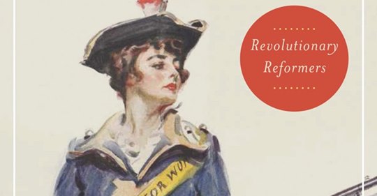
Massachusetts residents played a significant role in the Woman Suffrage movement, and author Barbara Berenson wrote an accessible and informative book, titled Massachusetts in the Woman Suffrage Movement.  We encourage you to learn more about the book by clicking on the image below to go to the webpage for the book and you can click on the button below to hear an audio interview of the author.

Radio Interview with Barbara Berenson
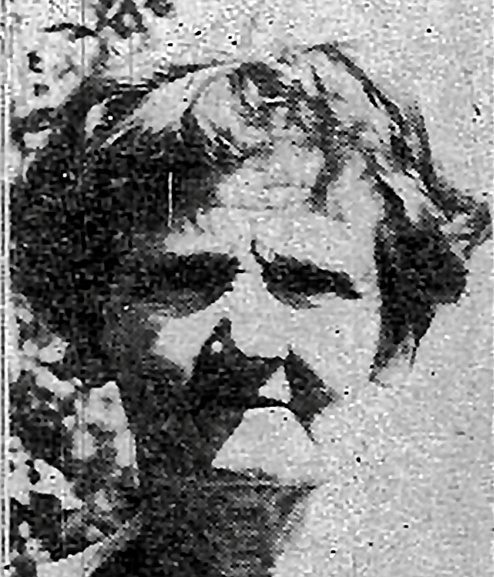
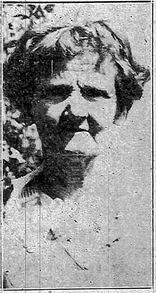

Phoebe Jordan

Berkshire County’s second most famous suffragist is Phoebe Sarah Jordan (1864-1940) of New Ashford, MA, and yet few County residents know who she was, why she is noteworthy, or have seen a photo of her, even though there are people still alive today with childhood memories of her.

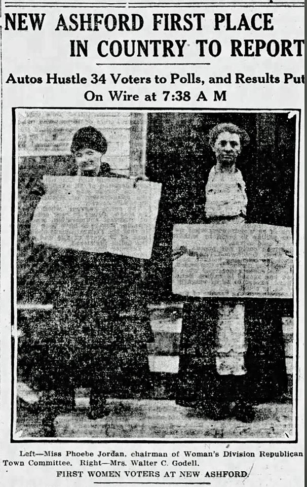
Her current claim to fame is that she was the first American woman to legally vote in a presidential election in November of 1920, after the ratification of the 19th Amendment. But that is not the headline on her Berkshire Eagle obituary.

For five national elections, from 1916-1932, New Ashford was the first town in the nation to cast its ballots (Dixville Notch, NH, usurped that honor at the 1936 election) thanks to a publicity scheme cooked up by Dennis J. Haylon, managing editor of the Berkshire Eagle, and Carey S. Hayward, city editor of the Pittsfield Journal, to open the polls in what was then the Commonwealth’s smallest town, at 6 am. With the cooperation of the three dozen or so voters, it was possible for New Ashford to be the first community to report election returns.


Boston Globe, November 3, 1920

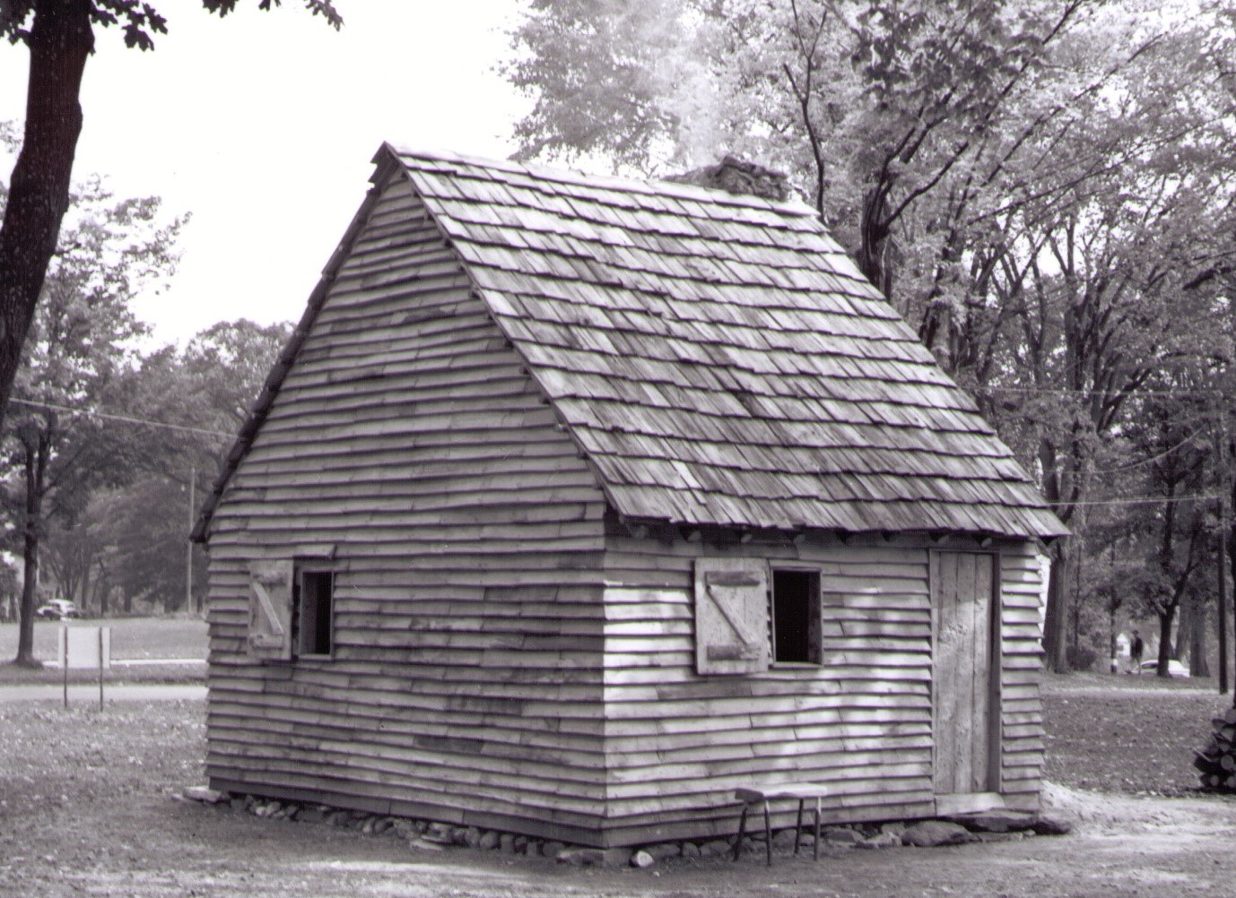
Elections were held in what was then the schoolhouse on Mallery Road – since restored and known as the 1792 Schoolhouse, and since automobiles – not to mention paved roads – were still a novelty in 1916, many voters, including Jordan, arrived on foot.

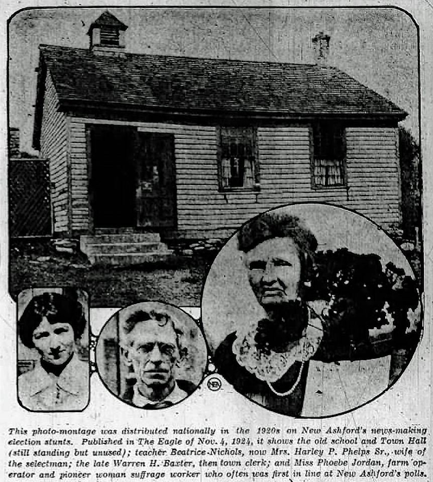
 Photo montage of New Ashford 1792 schoolhouse, Beatrice Nichols Phelps, Warren H. Baxter and Phoebe Jordan in a Berkshire Eagle retrospective article August, 1955.
1792 Schoolhouse, New Ashford
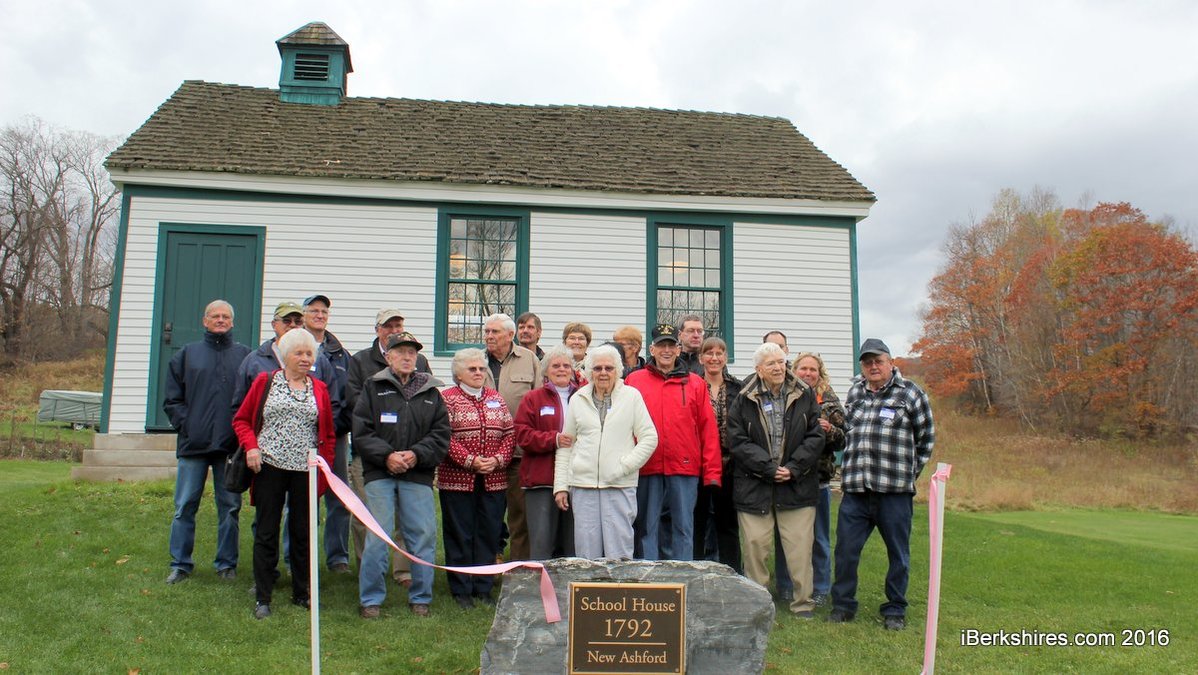
iBerkshires photo of the alumni of the 1792 Schoolhouse at the opening of the restored building in November 2016

Who was this first American woman to legally cast a vote in a Presidential election?

Phoebe Jordan was the quintessential New Englander. Born to Emily Middlebrook and Sidney Deloss Jordan in Washington, MA, on February 26, 1864, she came to New Ashford to live with her aunt, Miss Josephine Jordan, when she was seven and never left.

Her grandfather, Francis Jordan, had arrived in New Ashford in the early 19th century. All the town’s farmers gathered to help him “raise” his house in May of 1831.

When other family members passed away Phoebe Jordan came to run the farm, which eventually grew to 400 acres. Though weighing not more than 100 pounds she did much of the work herself, having no more than two hired men to help her.

She was an expert at operating a horse-drawn mowing machine and in the winter she operated a similarly powered snow plow. She raised prize winning turkeys. She supplied the schoolhouse with its annual allotment of firewood. She was an expert marksman and killed a fox caught robbing her chicken coop with one shot at a distance of 102 feet. She never married.

For 12 years she was the owner and operator of New Ashford’s sole non-agricultural industry – a charcoal kiln, one of the last in the County – until the top of the cone caved in after a big snowstorm in 1931, burying 15 cords of hardwood.

Like her Aunt Josephine before her, she drove her heavily-laden two-horse farm wagon 12 miles to Pittsfield to sell her charcoal and farm produce. Her personal vehicle was an 1870 single-horse carriage, but her trek to the polls was usually made on foot.

So it is no surprise that this most independent and resourceful woman was a suffragist!

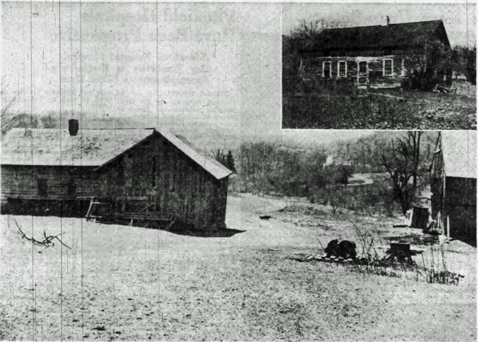
Jordan’s barns, c. 1940

We are told Jordan was a suffragist, but our local newspapers at the time carried little news of local suffrage efforts, beyond running cartoons skewering women’s demands for full enfranchisement.

We do know that, long before she could vote, she was the chair of the New Ashford Republican Committee, proving that women were actively involved in politics alongside the men before the passage of the 19th amendment.

And she was a big supporter of the PR stunt that made New Ashford the first town in the nation to vote and record its election results, so it was only natural that, as soon as she could vote, she showed up bright and early at the polls.

We saw that when the Boston Globe featured a photo of Jordan and another New Ashford woman who were the first to vote, the news wasn’t that they were women, but that they were the first citizens in the USA to vote in the 1920 presidential election.

The following year Jordan enthusiastically ran for a seat on the New Ashford Board of Selectmen – and garnered exactly one vote. Women may have been grudgingly welcome at the polls but not in the seats of power.

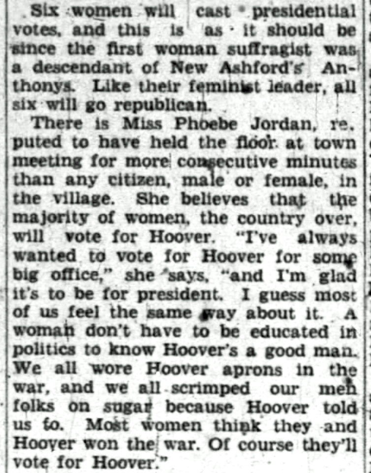
Still she continued to be a staunch Republican (see the clip from the Berkshire Eagle in July of 1928 below in which she explains at length why women support Herbert Hoover) until, in 1934, she “became dissatisfied with the manner in which the Republicans were running the state and the nation and left the party flat” after which she became “as firm a Democrat as she was a Republican” according to the North Adams Transcript.

When Jordan died in 1940 her obituary in the North Adams Transcript hailed her as the first person in the nation to cast their ballot in four consecutive presidential elections – 1920, 1924, 1928, and 1932.

It wasn’t until 1992 that she was publicly identified as the first woman to vote legally in a presidential election. And it was the effort, started in 2008, to raise money to restore the 1792 schoolhouse in New Ashford, that really began to capitalize on this feminist claim to fame for the building and the town. And it worked – in 2016 the town cut the ribbon on the restored schoolhouse and invited all living alumni to attend the ribbon-cutting ceremony.

The voting population of New Ashford turned out for a turkey supper and straw vote in advance of the 1936 presidential election, the first in which Dixville Notch, NH, usurped their status as first town in the nation to vote. Phoebe Jordan is seated in front, third from the right. The Berkshire Eagle 11-2-1936.

Do you have Suffrage stories to share?  We hope you will let us know if any stories were passed down from the women in your families.  Email Sarah at sarah@williamstownhistoricalmuseum.org to tell us your story.


Discover Historic Williamstown! Week 9

Our final marker commemorates the location of a structure vital to the founding of our town: West Hoosac Fort.

In late May of 1754, a year after the first proprietors’ meeting in West Hoosac (Williamstown), native Americans attacked what is now Hoosick and Hoosick Falls, NY, about 12 miles downstream on the Hoosic River.

Arthur Latham Perry notes in Origins in Williamstown, 1894, “All the settlers at West Hoosuck immediately abandoned the place on news of possible approaching attack ravages below them; those who had families betook themselves to Fort Massachusetts, where they were not very welcome, and others returned to their homes over the mountain or into Connecticut.

Images of the 1930s reproduction of the Fort Massachusetts

This bold incursion taught two important lessons. It taught the people of Connecticut that they were much exposed to Canada by way of the Housatonic, and that they ought to help the “Bay” to defend the gateway of the Upper Hoosac…the other lesson taught…was, that Fort Massachusetts was not well placed to defend the frontier towns in what is now Berkshire from the French and Indians. It stood to one side of the hostile route. This…doubled the confidence of the West Hoosac settlers, who were at the same time soldiers, to demand of the General Court a fort of their own, to be manned by themselves.”
The Line of Forts from present-day Bernardston to Williamstown

Over the next two years several pleas for the establishment of a fort here were sent to Governor Shirley, but it wasn’t until this pathetic appeal in January, 1756, from William Chidester, that action was taken (spelling and capitalization original):

“Your Petitioner and Some others TO THE AMOUNT OF FIVE FAMILYS are left alone in said Westerly Township as he apprehends in Emmenant Danger of being Murthered, and their substance destroyed by the Common Enimy…”

Gov. William Shirley by Thomas Hudson
National Portrait Gallery

Perry continues to explain: “Governor Shirley issued an executive order on the 6th of February in accordance with Chidester’s request, authorizing him to build a blockhouse on the ‘Square,’ – that is, in the Main Street on the third eminence, — if he could induce a sufficient number of the proprietors to join him so as to complete the work by the 10th of March; otherwise to build the block house on his own lot, house lot No. 6, and afterwards to picket the front part of that lot and of the lot next west, house lot No.8.

Chidester only found encouragement to do the lesser thing. Benjamin Simonds, Seth Hudson, and Jabez Warren, three of the oldest homesteaders..chipped in to aid him in his work. These four men commenced at once to erect the blockhouse on the eastern line of No. 6 where it touched the Main Street and several others who had left on the alarm in 1754, and among them Nehemiah Smedley and Josiah Hosford and William Hosford…returned and aided in the work.

A typical blockhouse

Ten men from Fort Massachusetts served as a guard from February 29th to March 29th, when the block house was finished. We can not tell exactly when it was done, but we know that pickets were set after the manner of Fort Pelham [a block house located in Rowe, MA, and ordered abandoned in 1954] around the fronts of both of those lots, enclosing the two houses…A good well was also within the enclosure. This rude work, not very well placed, and not meeting the views of a considerable number of the resident proprietors, was called ‘West Hoosac Fort,’ and it had a history, as we shall see.”

“It was inevitable, in the nature of things, that jealousy should spring up between the newer and the older forts in one small valley,” writes Arthur Latham Perry, “Origins in Williamstown” 1894

In April of 1756, in obedience to this order, Captain Isaac Wyman detailed five men from Fort Massachusetts, under the command of Sergeant Samuel Taylor, to guard the new fort, in connection with the men who had built it. This put the new fort under the control of a subaltern of the old one. So West Hoosuck resident William Chidester went to Boston in April, and obtained a Sergeant’s commission from Governor Shirley and the authority to supersede Taylor in the command of the new fort.

Perry further notes: “There seems to have been another jealousy stirring in the minds of these men…namely, the antipathy between the Connecticut men and the men of the Bay. Chidester and his chief friends were from the southern colony; most of the other leading men were from the eastward. This colonial bickering had certainly broken out at Lake George the fall before…”

In May of 1756 there were rumors of an enemy approaching from the northwest. The block house had no artillery at all and just ten men as a garrison. In June Chidester again took a petition to Boston urging the General Court not to rebuild Fort Massachusetts – “which is a considerable part of it fell down and it is Daly expected that the rest will fall” – but to fortify West Hoosuck to fulfill the same purpose of protecting the western boundaries of the Colony.

On June 11, as Chidester was returning from Boston without much encouragement for his petition, a series of hostile operations by French and Indians forces began along the Hoosic River, which cost several lives.

The Line of Forts from The Line of Forts: Historical Archealogy on the Colonial Frontier of Massachusetts by Michael D. Coe, 2006

It had long been the custom to keep small scouting parties in motion from fort to fort, from the Connecticut to the Hoosic, and down that river to the Hudson, and then back again, as this was the main source of news. Benjamin King and William Meacham had been sent on such an errand down the Hoosic by Captain Wyman, when, returning, they fell into an ambuscade only about three-quarters of a mile from West Hoosuck Fort and both were killed.

A close up from the 1776 map of our region in Jeffrey’s The American Atlas: Or, A Geographical Description Of The Whole Continent Of America

The tribes or communities of Indigenous People in this region were referred to as the Schaghticoke and were a part of the Mohican nation.

Fifteen days after Benjamin King and William Meacham were been killed by natives in June 1756 , a detachment of thirteen soldiers from the encampment at Half Moon were on their way to Fort Massachusetts when they were surprised in the town of Hoosac (now called Hoosick Falls or Hoosick, NY) about thirteen miles downstream of the fort, Eight of them were killed and the remaining five captured.

The next day, a small party was sent from Fort Massachusetts by Captain Wyman to reconnoiter the ground and possibly bury the dead, but upon approaching the place they found a large group of Schaghiticoke people, and Wyman and his group retreated. General Winslow detached a corps from Half Moon, who took possession of the ground and buried the slain.

Arthur Latham Perry notes in Origins in Williamstown, “On July 11, 1756, as William Chidester and his son James and Captain Elisha Chapin were looking for some strayed cows along Hemlock Brook at some little distance from their fort on the hillside above the brook, an Indian volley killed the two Chidesters, and wounded Chapin, who was seized, carried off about sixty rods, and killed and scalped.

The Indians then pressed up the hill, opened fire upon the block house, killed the cattle in the vicinity, and soon after retreated into the woods. Nobody dared, apparently, to carry the news at once to the other fort; and it was only on the second day from the attack that Captain Wyman sent twenty men to search for the body of Captain Chapin, who found him and buried him in a decent manner and returned with his family to Fort Massachusetts.”

Seth Hudson succeeded to the command of the West Hoosac Fort upon William Chidester’s death in July 1756. More men were billeted at West Hoosuck, and ammunition and food were supplied from Fort Massachusetts, but the majority of settlers were unhappy with what they perceived as inadequate supplies of men and provisions. There continued to be a schism between settlers from Connecticut, and those from eastern Massachusetts, with the former in favor of building up West Hoosuck and the latter wanting to refortify Fort Massachusetts.

In January of 1757, twenty-one West Hoosuck settlers petitioned Boston to redress of their grievances, and in typical governmental fashion, a committee was formed and no action was taken.

Hudson petitioned again in April of that year with the result that Timothy Woodbridge, Esq., a frontiersman from Stockbridge was ordered to “repair to the western frontier, and examined fully into the state of affairs there.”

Woodbridge made a thorough examination of the lay of the land and listened to complaints and concerns from both sides and within a month presented a full report to the General Court in Boston that was much more favorable to the West Hoosuck settlers and their claims than anything before.

Woodbridge believed that Fort Massachusetts was only built where it was because no one knew any better at the time, and that “…the enemies chief gangway to the western frontiers is about the west part of the west Township.” They found Fort Massachusetts “much decayed but still in such condition as may answer for a while” without the expense of repair, while the block house at West Hoosuck was deemed “…a place of considerable strength and tolerable situation…” which being fortified and additionally manned could be “…maintained against a considerable force.” He further stated that almost all of the settlers complaints were valid and that adding an additional twenty men to the ten already billeted to West Hoosuck would be a “public service.”

Another part of the Woodbridge committee’s report related to the conduct of Captain Isaac Wyman in his capacity as commander at Fort Massachusetts, to Major Elijah Williams as commissary at the west, and to Colonel Israel Williams as commander of the entire western region. According to Arthur Latham Perry: “A large mass of testimony was taken, including numerous depositions, in behalf of, and in opposition to, the complaints of the petitioners, which papers, in confusing abundance, are now in the secretary’s office at Boston.”

Portrait of British General Jeffery Amherst by Joshua Reynolds.

The name of Lord Jeffery Amherst is not often mentioned in polite conversation in Williamstown these days, both from the historic rivalry between the colleges and Lord Amherst’s relentless attacks on indigenous communities during his lifetime, but in western Massachusetts in the 1750s-1760s he was a major contributor to the end of the French and Indian War, whose military victories had a direct impact on life in the upper Hoosic Valley.

Perry states, in his 1894 Origins in Williamstown, “From the moment that the military temper and resources of General Jeffery Amherst were understood in New England, let us say from Sept. 30, 1758, the individual importance of the two forts on the [Hoosic River] began steadily to decline, and of course also the bitterness and bickerings between them.

It is pleasant to note, that the last official request of the commander of the West Hoosuck Fort was, that his garrison and neighbors might share in the privilege of hearing the preaching of the chaplain at the older fort a part of the time.”

There had been no proprietors’ meeting called or held here for six years and six months, when Captain Isaac Wyman, still nominally the proprietors’ clerk, was requested to call one in September of 1760. Notably, he dated this meeting call “East Hoosuck,” not “Fort Massachusetts.”

Wyman had not relished the charges so persistently made against him as commander of Fort Massachusetts by his co-proprietors in West Hoosuck and he lost interest in the governance of this town. At that 1760 meeting William Horsford was chosen clerk in his place; and in November 1761 the Registry of Deeds records that “Isaac Wyman, Gentleman of Fort Massachusetts, sold to Benj. Kellogg of Canaan, Connecticut, for £140 all his lands in West Hoosuck, including his fine house lot No. 2, “

Wyman left western Massachusetts and moved to Keene, New Hampshire, where his tavern still stands today as an historic museum. Wyman Tavern was built in 1762 and is Keene’s most historic house.

Photo of Isaac Wyman’s Tavern in Keene, New Hampshire, taken before 1905

So where was West Hoosuck Fort? The following maps show it on the property along Field Park where the Williams Inn stood from 1974-2019. You’ll find this week’s historical marker and a boulder with a commemorative plaque at the west end of that lot.

In Origins in Williamstown (1894), Arthur Latham Perry writes about the demise of the West Hoosuck Fort and how, in the late 19th century, he could establish exactly where the block house stood,

“The decadence and final disappearance of West Hoosuck Fort was similar in its course to that of [Fort Massachusetts]. Besides the block house, there were two other houses within the pickets, all standing on the front of lots 6 and 8, the block house being on the eastern line of the third house lot (6) west of North Street, and the two other houses still further west, on the declivity towards Hemlock Brook. The picket line was 28 rods long on Main Street.how far the picket lines extended northward and consequently how much land was enclosed by them; there are no present means of determining; but the position of the blockhouse and the easterly line of pickets can be determined almost exactly….”

(Perry continues in great detail with the measurements!)

After the battles of the French and Indian War moved elsewhere and military protection became less necessary, at least four proprietors’ meetings were held within its rude walls of hewn timber until the Fort was abandoned in 1761.

 Were you able to find the site of the blockhouse and its marker, located at 1090 Main Street, in front of the former Williams Inn near Field Park.  We encourage you to get out and discover historic Williamstown.  As a repository for town artifacts and a research center, we encourage you to photograph your historic town and send your images by email to sarah@williamstownhistoricalmuseum.org.  Thank you and happy summer!

New Video Series! A Brief Introduction to Williamstown

For everyone interested in learning more about Williamstown’s history the Williamstown Historical Museum is offering a new online resource – videos that introduce students to the history of Williamstown. These brief videos, created by local students, are available to watch for free on the Museum’s website and on YouTube.

The first two videos “Beginnings” and “English Settlement,” focusing on the English settlement of Williamstown in the 1750s, are online now. Other videos focusing on farming, industry, and Williamstown as a 19th century resort community will be released in the upcoming months.

Recent Mount Greylock high school graduate Malcolm Skinner, is working with the museum to create the videos using images from local collections and voiceovers from local students. The voices heard on the current videos are Izabel Harding and Mia Harding. Future videos will be narrated by other local students including Effie Skinner and Rutledge Skinner.

Do you know a student who is interested in contributing to upcoming videos?  Let us know by emailing Sarah at sarah@williamstownhistoricalmuseum.org and we can get them started!

We invite you to view the videos by clicking the buttons below.

A Brief Introduction to Williamstown: Beginnings

A Brief Introduction to Williamstown: English Settlement

The Williamstown Historical Museum is located at 32 New Ashford Road in South Williamstown, on Route 7 just south of the Five Corners. Due to COVID-19 restrictions the Museum is currently closed to visitors, but there are lots of resources – scholarly articles, maps, images, and videos – available online at www.williamstownhistoricalmuseum.org.  Staff is available to help by emailing sarah@williamstownhistoricalmuseum.org